
Hurricane Arthur was the first tropical storm of
the season over the Atlantic Ocean. It became classified
as a tropical depression on 1 July with sustained wind speeds of 55 km/h. The National
Hurricane Center
forecast that the tropical depression would become a tropical storm later that
day. A tropical storm watch was issued.
At 11:00 AM
(EDT) the tropical depression gained its tropical storm status. It was located
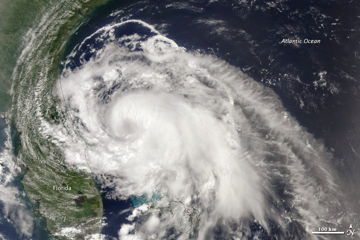
offshore of the Central Florida
Atlantic Coast
and was travelling northwest at 4 km/h with wind speeds of 65 km/h. At 11:00 PM (EDT), Arthur had wind speeds of 85
km/h and was travelling north at 4 km/h. The NHC issued a tropical storm watch
for east coast of Florida from Fort
Pierce to Flagler
Beach. It was predicted that Arthur
would gain strength and become a hurricane on 3 July with estimated wind speeds
of 110 km/h.
On 3 July at 5:00
AM (EDT) Arthur gained its hurricane status with wind speeds up to
120 km/h. It was not a Category 1 hurricane moving north at 15 km/h. The
minimum central pressure was 985 MB. Hurricane Warnings was extended to areas
northwards from Duck North Carolina to North Carolina/Virginia border.
At 9:00 PM
(EDT) on the same day Arthur became classified as a Category 2 Hurricane with
sustained maximum wind speeds of 160 km/h and minimum pressure of 976 MB.
Arthur was forecast to pass near or over the coast of North
Carolina and the Outer Banks. A maximum height of 5ft
storm surges was expected along coastal areas. This was due to the combination
of both the low pressure and high tide.
At 11:15 PM
(EDT) the center of Arthur made landfall over Shackleford Banks between Cape
Lookout and Beaufort North Carolina.
Sustained wind speeds of 155 km/h were recorded. The minimum central pressure
was 976 MB and the storm was moving north east at 30 km/h.
On 4 July Arthur continued to move northeast with
maximum sustained winds of 155 km/h, triggering numerous watches and warnings.
An increase in the forward speed was expected. According to the forecast track,
the center of Arthur would pass over coastal areas of eastern North
Carolina, southeast of New England
and be near or over western Nova Scotia
on Saturday 5 July. At 2:00 AM (EDT)
Arthur was moving up the west side of Pamlico Sound at
35 km/h.
Hurricane conditions continued to spread north
along the Outer Banks. At 5:00 AM
(EDT) Arthur was moving offshore of the Outer Banks and was expected to pass
southeast of Cape Code
later that night. At 8 AM (EDT) Hurricane Arthur kept moving away from the
coast of North Carolina at 34
km/h and began to weaken as it moved away. At 11:00
PM (EDT) Arthur's wind speeds had decreased to 120 km/h and the
minimum pressure center was 976 MB. The system was moving northeast at 50 km/h.
It was downgraded to a Category 1 Hurricane.
At 8:00 AM
(EDT) on 5 July, Hurricane Arthur became a post tropical cyclone as it moved
over southeast Canada
with winds of 100 km/h.
26 counties in North
Carolina declared a Sate of Emergency with evacuation
orders in place. The impacts of Hurricane Arthur were limited with no severe
structural damage reported. Several homes lost power due to the damaging wind.
Flooding along coastal regions was reported, however no fatalities or serious
injuries took place. An EF1 tornado was also reported in Duplin
County. The tornado damaged two
structures and numerous trees.
New Precipitation Satellite Sees First Atlantic Hurricane (NASA Video)

Source: Earthobservatory
Source: Earthobservatory

Source: NOAA

Source: Earthobservatory

Source: NOAA

Source: NOAA

Source: NOAA

Source: NOAA

Source: NOAA

Source: NOAA

Source: NOAA

Source: NOAA
Source: NOAA

Source: NOAA

Source: NOAA

Source: NOAA
Media Videos:
No comments:
Post a Comment