
On 25th April 06:11 (UTC) a shallow (15 km) magnitude 7.8
earthquake struck 34 km (21 miles) ESE of Lamjung in Nepal
causing devastation. The earthquake was felt as far away as southern India
including Karnataka and Kerala,
Bangladesh, Pakistan,
Bhutan and south
western China
including Tibet.

Location of the earthquake (Source: USGS)
A total 7250 people have been
confirmed dead on 3rd May and the number of fatalities keeps rising
everyday. The majority of deaths have occurred in Nepal
and a further 100 people have been killed in India
(78), China/Tibet (25) and Bangladesh
(4). In Nepal
the worse affected district is Sindhupalchok where 3,360 fatalities have been
confirmed. 14,021 people have also been injured including 200 in Bangladesh,
383 in China
and 288 in India.
The earthquake triggered an
avalanche on Mount Everest which claimed 19 lives at the
base camp. Several climbers had to be rescued by helicopters. It has not been
confirmed whether the route will reopen or remain closed for climbers since
extensive damage has been caused. Another avalanche triggered by the earthquake
destroyed the entire village of Langtang
leaving 250 people missing.

Deaths and injuries by districts on 1 May (Source: MapAction)
The earthquake has also triggered
several landslides, of which the ones reported are shown on the map below. Landslides
have not only damaged buildings and infrastructure but have also caused
temporary dams in rivers which could cause floods downstream when they fail.
Glacial lakes may also pose a risk due to the effects of the earthquakes and
landslides which could have weakened them leading to sudden draining in the
future. Further concerns are growing
regarding potential fatal landslides which could be triggered during the
monsoon next month.

Reported Landslide Locations (Source: Pacific Disaster Center)

Langtang Valley Landslides and damaged buildings (Source: Pacific Disaster Center)
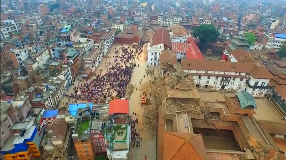
The capital Kathmandu
located 77 km (48 miles) from the earthquakes epicentre has been severely
impacted. Apart from damage to buildings and infrastructure, Kathmandu Durbar Square, a UNESCO World Heritage Site has
been destroyed along with numerous temples built decades and centuries ago. Dharahara tower built in 1832 has also
been destroyed and caused the death of an estimated 180 people.
Numerous villages in the surrounding
remote areas have suffered catastrophic devastation; some have been entirely
lost by the event.

Severity of Districts (Source: United Nations)
According to officials 160,786 buildings
have collapsed and 143,642 have been damaged. This figure may rise and be
confirmed as further damage assessments are carried out over the next few
weeks. The Government is projecting that the number of destroyed buildings
could total 500,000.
Some reports suggest ¾ of buildings
in the country have been left unsafe. In Gorkha and Sindupalchowk, the worse
affected districts, estimates suggest 90% of houses have been destroyed and in Dhading,
Dolakha, Rasuwa and Nuwakot districts more than 80% of houses have been
destroyed. Buildings have also been damaged or destroyed in neighbouring
countries such as Bihar and Odisha in India.
According to the Government 1383 schools have also been destroyed or damaged in
the 26 districts.
Several villages have not been
accessed yet due to landslides, damaged and destroyed infrastructure and lack
of communication. It is likely that the number of fatalities and damaged
buildings will increase over the next few days as the true scale of the
disaster becomes clear.

Collapsed and damaged public buildings by district (Source: MapAction)

Collapsed and damaged government buildings by district (Source: MapAction)

Preliminary damage assessments (Source: Pacific Disaster Center)

Preliminary damage assessments (Source: Pacific Disaster Center)

Preliminary damage assessments (Source: Pacific Disaster Center)

Preliminary damage assessments (Source: Pacific Disaster Center)

Preliminary damage assessments (Source: Pacific Disaster Center)
Search and rescue efforts are now
beginning to slow down as the likelihood of finding survivors is very low. Many
have been pulled out alive from the rubble days after the earthquake. On 3rd
May a 101 year old man was found alive 7 days after the earthquake. Current
concerns have now shifted from search and rescue to relief including the
provision of aid to the victims.
Thousands are still in need of
essentials such as shelter, food and water. Many isolated villages in the
mountains have yet to receive any aid. Relief efforts have been further
hampered by rain, continuing aftershocks and landslides, damaged and destroyed
infrastructure including roads, power outages and lack of communication and
coordination. A ban on large planes flying to the airport has posed a challenge
for agencies trying to fly aid into the country. Concerns are also growing over
the approaching monsoon season which could worsen the conditions.
The United Nations and its
Partner organisation have stated in their report released on 3rd May
that $415 million is needed for vital humanitarian relief, 3 million people are
in need of food aid and 24,000 people are currently living in temporary
shelters. An estimated 28 million people have been affected by the earthquake
according to the UN.

Humanitarian Infrastructure (Source: MapAction)
Aerial images released have shown
the shocking destruction caused by the earthquake in Nepal.
According to reports the earthquake has caused over £3.3 billion worth of
damage and over £6.5 billion will be required for reconstruction. Being one of
the poorest countries in the world, Nepal
will require assistance to deal with the aftermath and economic cost of the
disaster.
Science behind the earthquake
The earthquake was generated by a
convergent/diffuse plate boundary where two continental plates (Indian and
Eurasian) are colliding to form the Himalayas mountain
range. The Indian plate boundary is moving northward and being subducted by the
Eurasian plate at a rate of 40-50mm/year. The earthquake was a result of a
thrust fault between these two plates and the fault area is an estimated
~120x80 km.
This region is one of the most
seismically active regions in the world and experiences numerous earthquakes
including a magnitude 8 in 1934 which resulted in 10,600 fatalities.
The map below shows the tectonic
summary of the region and the shake map from the earthquake.

Tectonic summary (Source: USGS)

Cross section of slip distribution (Source: USGS)

Surface projection of slip distribution (Source: USGS)

Seismic Hazard Map (Source: USGS)

Shakemap of the earthquake showing intensity felt across the region (Source: USGS)

Community Internet Intensity Map showing the intensity felt by the public (Source: USGS)

Peak Acceleration Map (Source: USGS)

Peak Velocity Map (Source: USGS)
Satellite images acquired by ESA before
and after the earthquake have shown land displacement. These images are shown
below. According to the data Mount Everest shrank by
about an inch and land around Kathmandu was lifted 1
metre.

(Source: European Space Agency)


(Source: European Space Agency)

Summary of the displacement (Source: Incorporated Research Institutions for Seismology IRIS)
Seissound animation from IRIS:
The link below is for
Incorporated Research Institutions for Seismology. They have some very
interesting technical details of the earthquake including a single fault model
and some useful links:
Aftershocks
Hundreds of aftershocks have
occurred varying in size after the main earthquake including a magnitude 6.6
located 49km (30 miles) east of Lamjung on 25th April at 6:45 (UTC)
and a magnitude 6.7 located 19km (12 miles) SSE of Kodari on 26th
April at 07:09 (UTC).
According to the USGS the
probability of further aftershocks is now lower than their 27th
April forecast due to the decreasing number of occurring aftershocks at a
faster rate than expected. However, even though there will be fewer,
aftershocks will continue to occur over the next few weeks or even months.
These may increase the risk of further damage and landslides.
The preliminary numerical
forecast table below by the USGS shows that there is a 78% probability of a
magnitude greater than 5 of occurring and a 14% probability of a magnitude greater
than 6 occurring between 1st and 7th May. This
information will be updated each week and can be found on their website.

Numerical Forecast for aftershocks (Source: USGS)
Appeals and further information
To find out more about the Nepal Appeal and to Donate to DEC, visit:
For the latest disaster response maps, visit:
Updated information on Nepal from Reliefweb:
United Nations Daily Reports of the response and relief efforts:
Useful response maps:
NASA will be positing images of the disaster on the link below:
Earthquake Damage photos and videos


Aerial Images of the damage (Source: BBC)

Aerial Images of the damage (Source: BBC)

Aerial Images of the damage (Source: BBC)
Aerial Images of the damage (Source: BBC)

Humane Society International are on the ground helping animals who are suffering as a result of the earthquake (Source AP)


Damage on Everest after earthquake triggered an avalanche


The video below show the avalanche on Everest Basecamp triggered by the earthquake (please note the video contains inappropriate language)
No comments:
Post a Comment