
Calbuco, located in southern Chile erupted without warning on 22nd April 2015 leading to the evacuation of thousands of people. The volcano has a summit of 2003m (elevation: 6570ft) and is one of the most active volcano in the region.
Two confirmed VEI 5 eruptions have taken place in the past, dated 8460 (+/-155) and 6760 (+/-825) and six VEI 4 eruptions have also taken place. The last eruption was a VEI 2 on 26th August 1972 . The table below shows a summary of the eruptions at Calbuco.
Start Date
|
Stop Date
|
Eruption Certainty
|
VEI
|
Evidence
|
Activity Area or Unit
|
1972 Aug 26
|
1972 Aug 26
|
Confirmed
|
2
|
Historical Observations
|
|
1961 Feb 1
|
1961 Mar 26 (in or after)
|
Confirmed
|
3
|
Historical Observations
|
|
1945
|
Unknown
|
Confirmed
|
Historical Observations
|
||
1932
|
Unknown
|
Confirmed
|
Historical Observations
|
||
1929 Jan 6
|
1929 Jan 6
|
Confirmed
|
3
|
Historical Observations
|
|
1917 Apr
|
1917 May
|
Confirmed
|
3
|
Historical Observations
|
|
1911
|
1912
|
Confirmed
|
2
|
Historical Observations
|
|
1909 Mar
|
Unknown
|
Confirmed
|
2
|
Historical Observations
|
|
1907 Apr 22
|
Unknown
|
Confirmed
|
2
|
Historical Observations
|
|
1906
|
Unknown
|
Confirmed
|
2
|
Historical Observations
|
|
1894 Nov 16
|
1895 (?)
|
Confirmed
|
2
|
Historical Observations
|
|
1893 Jan 7
|
1894 Jan 16 (in or after)
|
Confirmed
|
4
|
Historical Observations
|
|
[ 1837 ]
|
[ 1838 ]
|
Discredited
|
|||
1792 (?)
|
Unknown
|
Confirmed
|
Historical Observations
|
||
1600 ± 75 years
|
Unknown
|
Confirmed
|
Radiocarbon (uncorrected)
|
||
1380 ± 50 years
|
Unknown
|
Confirmed
|
Radiocarbon (uncorrected)
|
||
0710 ± 60 years
|
Unknown
|
Confirmed
|
4
|
Radiocarbon (corrected)
|
Ca13 tephra layer
|
0520 ± 200 years
|
Unknown
|
Confirmed
|
Radiocarbon (uncorrected)
|
||
0220 ± 75 years
|
Unknown
|
Confirmed
|
Radiocarbon (uncorrected)
|
||
0160 ± 135 years
|
Unknown
|
Confirmed
|
4
|
Tephrochronology
|
Ca12 tephra layer
|
0040 ± 75 years
|
Unknown
|
Confirmed
|
Radiocarbon (uncorrected)
|
||
0100 BCE ± 100 years
|
Unknown
|
Confirmed
|
Radiocarbon (uncorrected)
|
||
0330 BCE ± 200 years
|
Unknown
|
Confirmed
|
Radiocarbon (uncorrected)
|
||
1920 BCE ± 50 years
|
Unknown
|
Confirmed
|
Radiocarbon (uncorrected)
|
||
4300 BCE ± 150 years
|
Unknown
|
Confirmed
|
Radiocarbon (uncorrected)
|
||
5030 BCE ± 180 years
|
Unknown
|
Confirmed
|
4
|
Radiocarbon (corrected)
|
Ca11 tephra layer
|
5820 BCE ± 880 years
|
Unknown
|
Confirmed
|
4
|
Tephrochronology
|
Ca10 tephra layer
|
6300 BCE ± 1035 years
|
Unknown
|
Confirmed
|
Tephrochronology
|
Ca9 tephra layer
|
|
6760 BCE ± 825 years
|
Unknown
|
Confirmed
|
5
|
Tephrochronology
|
Ca8 tephra layer
|
7550 BCE ± 45 years
|
Unknown
|
Confirmed
|
4
|
Radiocarbon (corrected)
|
Ca7 tephra layer
|
7930 BCE ± 275 years
|
Unknown
|
Confirmed
|
Tephrochronology
|
Ca6 tephra layer
|
|
7990 BCE ± 290 years
|
Unknown
|
Confirmed
|
Tephrochronology
|
Ca5 tephra layer
|
|
8100 BCE ± 1300 years
|
Unknown
|
Confirmed
|
Tephrochronology
|
Ca4 tephra layer
|
|
8210 BCE ± 290 years
|
Unknown
|
Confirmed
|
Tephrochronology
|
Ca3 tephra layer
|
|
8320 BCE ± 250 years
|
Unknown
|
Confirmed
|
Tephrochronology
|
Ca2 tephra layer
|
|
8460 BCE ± 155 years
|
Unknown
|
Confirmed
|
5
|
Radiocarbon (corrected)
|
Ca1 tephra layer
|
Table Source: Global Volcanism Program
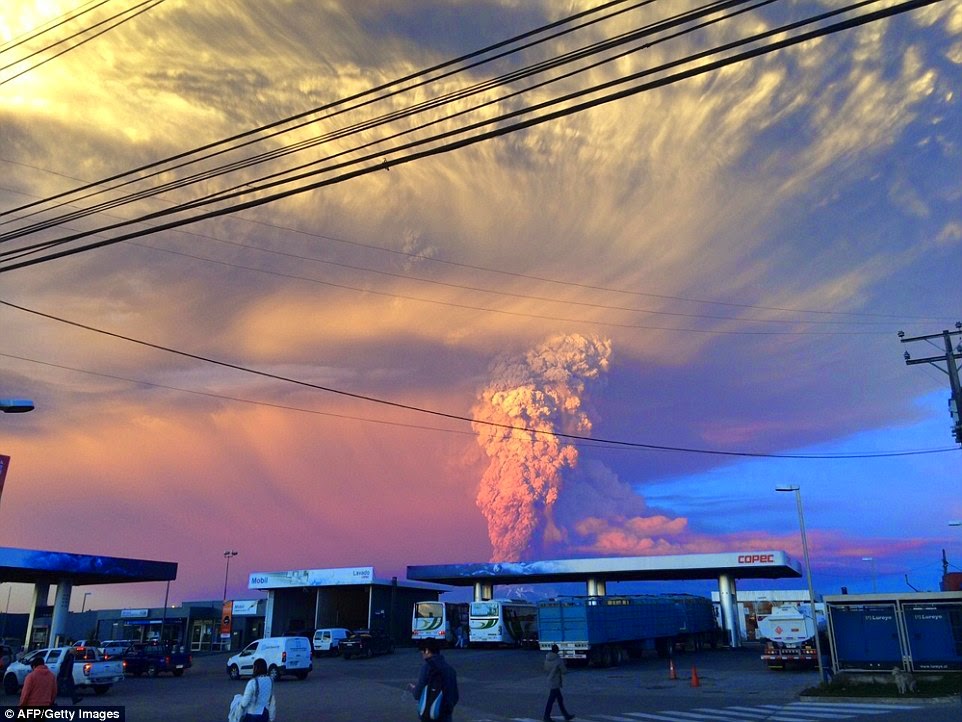
On 22ndApril an hour before the first eruption volcano-seismic activity was detected, of which the largest occurred at 17:35 . At 18:04 Calbuco erupted spectacularly sending a sub-Plinian ash column 15 km into the atmosphere. The ash column travelled north, northwest and east from Calbuco. The eruption lasted 90 minutes and authorities raised the Alert Level to Red and placed a 20 km exclusion zone around the volcano.
On 23rdApril at 01:00 a second larger eruption took place, generating a sub-Plinian ash column over 15 km into the atmosphere. The eruption lasted six hours and the ash column travelled north and east from Calbuco. According to the Global Volcanism Program, six vents on west, southwest, and south of the old lava dome were the source of the ash emissions.
SERNAGEOMIN estimated 210 million cubic metres (7420 million cubic feet) of ash has been emitted during the eruptions. An estimated 0.3-0.4Tg of sulphur dioxide emissions was also detected 21 km into the atmosphere on 28th April.


Concentration of sulphur dioxide between 23-26 April. (Source: Earth Observatory)
Lava bombs, including incandescent tephra were ejected within a distance of 5 km during the eruptions and pyroclastic density currents generated by the eruption travelled a distance of 7 km. Lahars travelled a distance of 15 km. SERNAGEOMIN issued hazard maps (shown below) highlighting areas at risk.
Source: Servicio Nacional de Geología y Minería (Sernageomin)
The map shows are susceptible to lavas, lahars and pyroclastic density within a radius of 15 km. In larger eruptions pyroclastic density currents can travel as far as 25 km.
Source: Servicio Nacional de Geología y Minería (Sernageomin)
Source: Servicio Nacional de Geología y Minería (Sernageomin)
A total of 6514 people in the town of Puerto Montt and regions of Lago Chapo, Chamiza and Correntosowithin the 20 km exclusion zone were evacuated and are currently living in temporary shelters. Fortunately no fatalities or injuries have been reported.
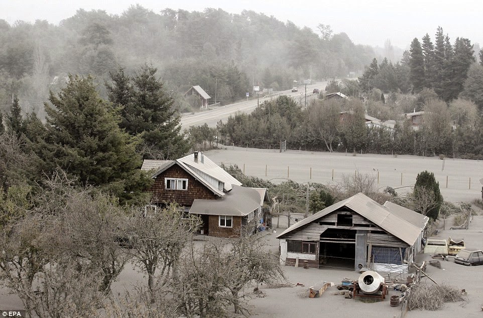
Cities and towns as far away as 70 miles, including those in Argentina located north east of Calbuco have experienced ash falls. Buildings, rivers, farms, infrastructure including roads have all been covered by tephra. Roofs of a few buildings in the vicinity of the volcano have collapsed due to the weight of tephra. According to studies by Spence et. al., (2005) the weakest buildings start collapsing when the ash load is 2kPa (20 cm). After 10kPa (100 cm) most buildings face a 100% probability of collapse and virtually no roof will have a chance of survival at a load of 20kPa (200 cm).
Animals have also suffered due to the eruption and the fishing industry has faced substantial losses. The eruption also caused disruption to international flights across cities and led to the cancellation or delay. Shown below are examples of the maps released by Buenos Aires Volcano Ash Advisory Centre during the eruptions in relation to the ash column.
Source: Buenos Aires VAAC
Source: Buenos Aires VAAC
 Source: Buenos Aires VAAC |
After the two large eruptions, the Alert Level remained Red due to the emission of smaller ash columns reaching heights of less than 2 km and volcano-seismicity. Although a few residents were allowed in and out to collect personal belongings the exclusion zone remains. Lahars continue to pose a risk and residents are strongly advised to stay away from the vulnerable exclusion zone in particular 200 m around the volcano.
On 30th April at 13:09 Calbuco has begun to erupt for the third time and is currently continuing to erupt. The current eruption is less powerful than the other two and the ash column has erupted less than 5 km into the atmosphere. Further updates on the eruption will be posted when information becomes available.
Satellite image from 24 April showing the ash and gas plume. (Source: Earth Observatory)
Satellite image from 24 April showing the ash plume. (Source: Earth Observatory)
Satellite image from 23 April showing the ash plume (Source: Earth Observatory)
Satellite image from 23 April showing the ash plume (Source: Earth Observatory)
Satellite image from 23 April showing the ash plume (Source: Earth Observatory)
Nighttime satellite image from 23 April showing the ash plume (Source: Earth Observatory)
No comments:
Post a Comment