
Widespread
devastation has been caused by cyclone Pam after it struck Vanuatu on 13th March.
Official
figures from OCHA claim that there are now 11 confirmed fatalities. The death
toll figures have varied from 16 to 24 but revised to 11 on 22nd
March. According to reports fatalities occurred on the island
of Tafea, Efate and Tanna.
166,600
people have also been affected on the nations 22 islands, 3392 are currently
living in 30 evacuation centres set up and 65,000 are in need of temporary
shelter.
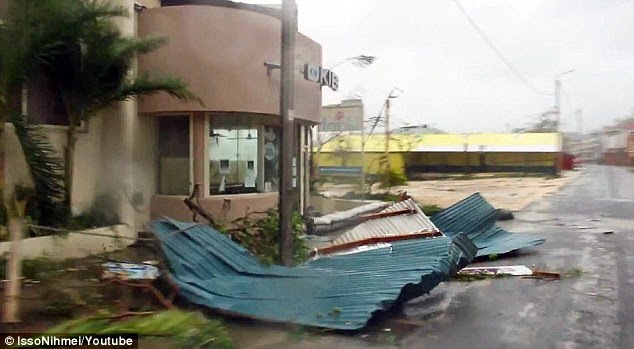
Infrastructure
such as bridges, roads, and power and communication lines have been damaged or
destroyed, making it difficult or impossible to reach the other islands. Officials
claim that 20% to 90% of homes, schools, clinics and churches have been
destroyed. Some villages have witnessed 100% destruction. In the provinces of
Penama, Malampa, Shefa and Tafea, 14,000 homes are believed to have been
destroyed or damaged by Pam. The islands of Nanumaga, Nanumea, Nui, Tanna and Vaitupu
are the worst affected.
Crops
have also suffered damage or have been destroyed and fishing fleets and
livestock have been killed. Water and sanitation infrastructure have also been
damaged or destroyed raising concerns of access to safe drinking water and the
spread of diseases.
The number
of fatalities is unfortunately likely to increase as the isolated islands are
reached over the next few days. The true scale of the devastation will also
become clearer when an assessment is carried out across the islands.
A state
of emergency has been declared by officials who believe this could be the worse
disaster to be witnessed in the southern Pacific. Relief effort is currently
taking place with aid being provided to the victims. Shortage of food and
drinking water has been of concern over the last few days.
Cyclone
Pam also caused damage to other islands including Solomon Islands, Tuvalu and Kiribati. Flash floods caused by heavy rainfall and storm surge
affected the island of Tuvalu causing significant damage to infrastructure and agriculture.
A state of emergency has also been declared on this island nation. New Caledonia, Fiji and New Zealand were also
in the path of cyclone Pam. 30,000 people are believed to have been affected on
these islands.
Cyclone
Pam formed on 6th March, gradually intensifying to a tropical
depression on 8th March and gaining cyclone status on 9th
March. On 10th March Pam further intensified into a Category 3
cyclone and on 12th March it became an intense Category 5 storm with
maximum wind speed of 270 km/h (165mph) and lowest recorded pressure of 896 mbar. Cyclone Pam remained a Category 5 cyclone
for 36 hours and struck Vanuatu as a Category 5 storm. Pam weakened to a Category 4 on 15th
March and further weakened to an extratropical storm on 16th March.

TRMM satellite showing rain rate (Source: NASA)

Source: NASA

RapidScat showing sustained wind speeds (Source: NASA)

RapidScat showing sustained wind speeds (Source: NASA)

Source: NASA

Source: NASA

TRMM showing rate of rain and thurnderstorms (Source: NASA)

Source: NOAA

Source: NOAA

GPM satellite showing rain rate (Source: NASA)


No comments:
Post a Comment